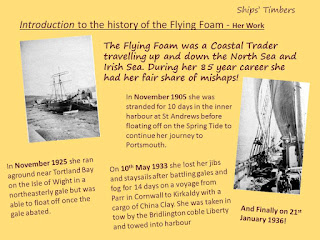
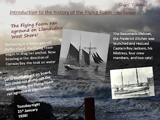
Across the weekend of 14th / 15th / 16th November 2014, the
Nautical Archaeology Society ran a series of events for us in Llandudno about nautical archaeology projects in Wales, and the practical skills needed to survey intertidal shipwrecks such as our Adopted wreck the
Flying Foam on the West Shore. The weekend was funded by
CADW, and all said it was a great weekend. Here's a summary of events.
Friday, 14th November, 2014
Refreshments provided by the West Shore Beach Cafe
The weekend of events started on the evening of Friday 14th November, 2014 with a talk given by Ian Cundy of the Nautical Archaeology Society. Our location for the evening was Llandudno Town Hall, and the title of the talk was 'An Introduction to Maritime Archaeology, and the Nautical Archaeology Society (NAS) plus A Maritime Archaeology Project: The Story Behind a Mystery Welsh Shipwreck'. Refreshments were provided for people as they arrived, by the
West Shore Beach Cafe. And what a delicious spread it was too! Tea and Coffee and homemade biscuits - Anglesey Shortbread, and Flapjacks.
Ian Cundy, NAS, giving his talk at Llandudno Town Hall
Forty people were in attendance at the Town Hall and everyone was gripped by Ian's depth of knowledge and very interesting narrative about nautical archaeology. We heard about some of the difficulties faced by archaeologists working in a marine environment in comparison to land based archaeologists. To explore and understand our submerged landscapes marine archaeologists face issues of limited visibility, tides, and sites which are extremely difficult to access generally. Some of the impacts which can affect a site include commercial impacts such as wind farms and tidal lagoon developments, trawler nets, dredging, and global warming. However, despite these issues, the marine environment can offer excellent preservation conditions in comparison to land based sites. And for anyone wanting to get involved in this type of work, the Nautical Archaeology Society (NAS) is the best place to start. The Nautical Archaeology Society (NAS) started out in 1964 as the Council for Nautical Archaeology (CNA) which had the remit to act as a channel of communication between divers and the appropriate learned bodies to share discoveries within the field of marine archaeology. NAS has evolved over the years to become a Society not just for divers but for anyone who has an interest in the marine and coastal environment, and its associated heritage. There are many ways to get involved in NAS through its membership such as training courses, the Adopt a Wreck Project, events, newsletters, and a dedicated academic journal - The International Journal of Nautical Archaeology (IJNA).
Highlighting some of the difficulties facing underwater archaeology, Ian went on to tell us about a wreck known as the Diamond. The Diamond was a three-masted square rigger, built in New York in 1823. She was one of the first ships to operate a regular service for passengers and cargo between Britain and the United States. Sadly, the Diamond sank in Cardigan Bay, en route to Liverpool from New York on 2nd January 1825. The alleged wreck site was identified in 2000 and was designated under the Protection of Wrecks Act 1977 on 1st April, 2002, the first such designation made by the National Assembly of Wales. However, the identification has since been called into question. In 2002, Ian was granted a license to investigate the wreck. His findings cast serious doubt on whether the designated wreck site is that of the Diamond, as it appears to be that of a larger and later (unidentified) vessel. Metal samples scattered on the site were stamped Muntz Metal, an alloy not patented until 1832, several years after the loss of the Diamond. Wooden samples taken from the main ribs and professionally analysed show that the wood was still growing at the date of the wreck of the Diamond (1825), and was not felled until around 1840! The mystery continues....

Deanna Groom from the Royal Commission on the Ancient and Historic Monuments of Wales
Friday 14th November, 2014 was also Children in Need Appeal Night. We brought some collection buckets to the talk, and are delighted to say that we collected £46:05 during the course of the evening. Thank you / Dioloch.
Saturday 15th November, 2014
Day one of the hulk recording survey skills started with 2D survey methods. This method is used on sites where features are flat. First we covered the basics of the theory which includes making a site sketch / plan and taking photographs before starting any measured recording. Then we covered the basic methods of offsets, trilateration, and ties.
Pre-fieldwork Risk Assessment and Health and Safety Talk
Before going out on site Bill Turner (NAS Tutor) gave the group a short pre-field work risk assessment talk. Then equipped with measuring tapes and check sheets the survey team set forth onto the beach.


Although the intention for the weekend was to survey the Ships' Timbers Adopted Wreck, the Flying Foam, the tidal conditions on the day did not allow that so we opted to practise skills on a different feature on the upper foreshore on the west shore.
The feature was already known to Ships' Timbers before the weekend and some concern had been expressed to the local Authority at one of the Llandudno Coastal Forum meetings that it might be covered over by the forthcoming beach replenishment which is scheduled for next year. So this was an ideal opportunity to further understand, and raise the profile of the feature.
Ian decided to do some small scale excavation work on the feature. Initial thoughts before the weekend were that the structure might be remains of a wooden groyne or jetty, but with the timber base it does not seem to be that!
Planning frame drawings were useful to record the feature in more detail, and one team member noticed the presence of nails every 5inches. It helps to focus on the details!
At the end of day one we all returned to a room at the Llandudno Town Hall to analyse results. We used scale drawings to recreate our results adding the planning frame drawings. A super day of survey work.
Sunday 16th November, 2014
Our second day of survey work focussed upon 3D methods. This is used for recording artefacts that are uneven and where parts of the structure are obscured from a direct line of sight. Again we start with a site plan / sketch and take photos. We then add a series of control points (about 8) around the site, label the parts of the feature we wish to record in our survey and take a series of measurements from each point to a minimum of four control points. A dumpy level is used to measure the depth (height) of the parts of the feature we wish to survey. It is very straight forward.
At the end of Day two we then went to Blind Veterans - Llandudno to analyse the results using some software called Site Recorder.
Final Thoughts
Upon completion of the two day survey training and from attending the talk on nautical archaeology, many more people are now more aware of the benefits and limitations of doing maritime archaeology. Ships' Timbers certainly is better equipped to draw on more people with an ability to carry out survey work on the foreshore with subsequent data analysis. This will really help when we come to survey the Flying Foam.
And finally, do we know what our west shore survey feature is? No not yet. So just like the Diamond - the mystery continues!
Acknowledgements
Ships' Timbers would like to thank CADW for providing the funding for this weekend event, to the Nautical Archaeology Society and Ian Cundy and Bill Turner for their knowledge and professional instruction in the delivery of the talk and course across the weekend on the west shore, to the West Shore Beach Café for letting us use their café for the theory part of the course and for the marvellous refreshments provided at the talk in the Town Hall, to Blind Veterans - Llandudno for the use of the IT facilities, to everyone who attended the talk at Llandudno Town Hall and also to those who gave a donation to help the Children in Need Appeal, and to everyone who attended the Survey Days on the west shore Llandudno.


